


Mid-Week Forecast and Gulf Coast System Outlook
- Sandi Saulsbury
- Jul 16, 2025
- 2 min read

Updated: Jul 16, 2025
12News Meteorologist Patrick Vaughn, Jeff Gerber, Kerry Cooper
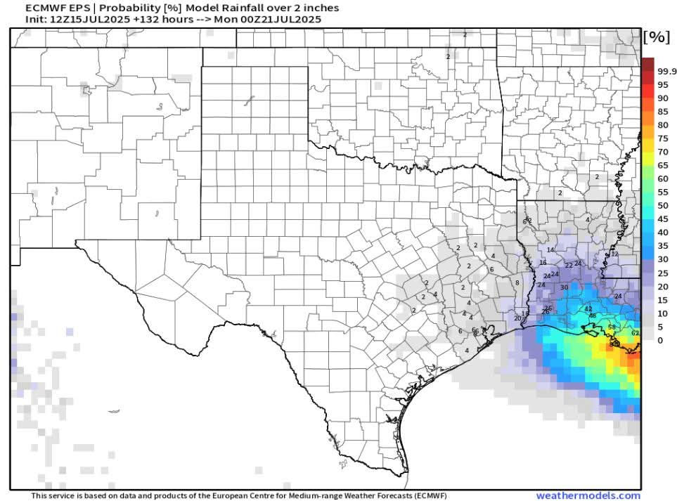
1-2 inches of rain is forecast across Southeast Texas through Sunday mainly falling Thursday night and Friday. Of course, higher totals are possible.

Wet weather likely late Thursday and Friday. Back to hot and dry next week due to building upper level high pressure.

Low pressure on land near Panama City continues moving west. Shower and thunderstorm activity is mainly to its southwest. Likely to reach SE Louisiana late Thursday. Rainfall estimates per modeling have decreased...will stick with 1-3 inches.
Forecast Discussion
Weak low pressure is in the North Central Gulf heading towards Louisiana. It's surge of tropical moisture will spread into Southeast Texas from the east late Thursday afternoon and persist through Friday ahead of drying this weekend.
Scattered, late afternoon showers and thunderstorms are forecast Thursday.
Thursday night and Friday, rain looks likely and it could be heavy at times with lower chances expected Saturday. 1-2 inches are forecast with higher totals possible.
Back to hot, humid and dry weather conditions much of next week as upper-level high pressure builds over the area. Afternoon highs will inch upwards into the middle 90s.
Short Term Forecast
Triangle Wednesday Night: Partly cloudy, warm and humid. Low near: 75° in Beaumont, 76° in Orange and 79° in Port Arthur. Winds: South-Southwest: 2-5 mph becoming Calm.
Lakes Area Wednesday Night: Partly cloudy, warm and humid. Low between: 74°. Winds: Calm.
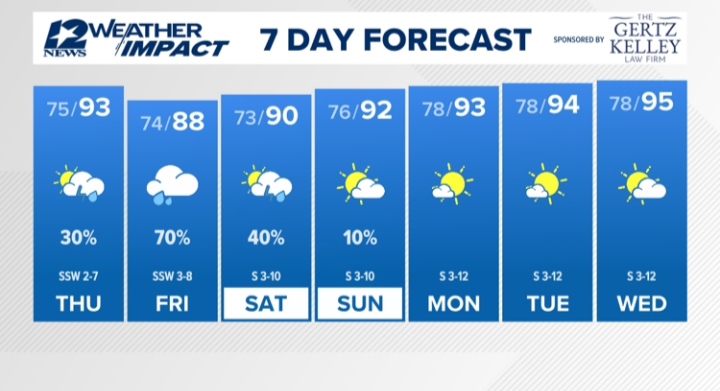
Triangle Thursday: Increasing cloudiness, hot and humid with a 30% coverage of late-afternoon showers and thunderstorms. High near: 93° in Beaumont, near: 91° in Orange and near: 90° in Port Arthur. Winds: South-Southwest: 2-7 mph.
Lakes Area Thursday: Increasing cloudiness, hot and humid with a 30% coverage of late-afternoon showers and thunderstorms. High near: 93°. Winds: Southwest: 2-5 mph.
Extended Forecast
Friday (7/18): Cloudy, warm and humid with a 70% coverage of rain and thundershowers…heavy rain is possible. Low near: 74°. High near: 88°. Winds: South-Southwest: 3-8 mph.
Saturday (7/19): Partly sunny, warm and humid with a 40% coverage of rain and thundershowers. Low near: 73°. High near: 90°. Winds: South: 3-10 mph.
Sunday (7/20): Partly cloudy, hot and humid with a 10% coverage of showers and thunderstorms. Low near: 76°. High near: 92°. Winds: South: 3-10 mph.
Monday (7/21): Mostly sunny, hot and humid. Low near: 78°. High near: 93°. Winds: South: 3-12 mph.
Tuesday (7/22): Mostly sunny, hot and humid. Low near: 78°. High near: 94°. Winds: South: 3-12 mph.
Wednesday (7/23): Partly cloudy, hot and humid. Low near: 78°. High near: 95°. Winds: South: 3-12 mph.

.png)


