


Busy Day Continues for Beech Grove VFD with Successful Woods Rescue
- Rita Shipp

- Dec 21, 2025
- 4 min read

JASPER COUNTY, Texas — After responding to multiple emergency calls earlier in the day, the Beech Grove Volunteer Fire Department was dispatched again Saturday evening, closing out an already demanding day with a complex woods rescue that highlighted teamwork, technology limitations, and the critical role of 911 dispatchers.
At 5:44 p.m., Beech Grove VFD was dispatched to assist with locating a lost motorist who had become stuck in the mud in a wooded area that was not clearly defined. The situation quickly developed into a coordinated search involving the Jasper County Sheriff’s Office - TX, Martin Dies, Jr. State Park - Texas Parks and Wildlife State Park Police, and Jasper County Sheriff’s Office 911 telecommunications operators.
According to Beech Grove VFD Fire Chief James Gunter, the excellent work of JCSO 911 dispatchers was instrumental in the successful outcome.
“The excellent work of the Jasper County Sheriff’s Office 911 dispatchers with pinpointing his location through the 911 system is how we found him,” Chief Gunter said. “Otherwise, he might still be there. They were able to narrow the area down to be searched.”
Using information provided through the 911 system, responders were able to focus their efforts on the Turkey Track Hunting Club area off County Road 150, significantly reducing search time in the remote, heavily wooded terrain.
First vehicle found — but not the one they were looking for
As deputies and state park police searched the hunting club road, they located a vehicle stuck in the mud approximately one mile in. Chief Gunter confirmed that the vehicle belonged to the son of the lost motorist, who had entered the area in an attempt to locate his father but became stuck himself.
After assisting with pulling the son’s vehicle free, Beech Grove VFD continued deeper into the area.
Deep woods, heavy terrain, and an unlikely vehicle
Firefighters proceeded in Brush 11, a 1995 Ford Super Duty equipped with four-wheel drive, mud-grip tires, and a winch — equipment that would soon prove essential.
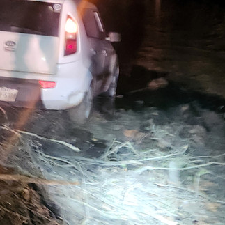
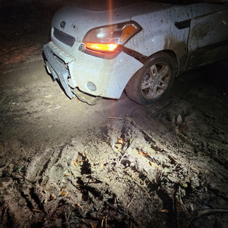
At approximately 2.8 miles in, at the end of the road in the Neches River bottomlands and a logging set, responders located the missing driver.
The motorist had driven a Kia Soul, a two-wheel-drive vehicle, into terrain typically accessed only by heavy logging equipment such as skidders and shears. Firefighters reported finding multiple pieces of the vehicle scattered along the hunting club road as they made their way in.
Chief Gunter noted that it was remarkable the vehicle made it as far as it did.


Photos Courtesy of Beech Grove VFD
How the driver ended up there
When asked how he became stranded, the driver explained that he had been traveling from Jasper back toward Woodville via U.S. Highway 190 earlier that afternoon. Due to the wreck at the Dam B Bridge — which required the bridge to be closed — he relied on GPS mapping to reroute around the scene. That reroute ultimately led him off the highway and deep into the wooded area where he became stuck.
Chief Gunter emphasized that the driver was not being reckless, but rather misled by mapping technology.
“In the driver’s defense, his Google Maps showed that road as County Road 152,” Gunter said. “It even showed it as a cut-through between CR 150 and CR 151, but it is not.”
Chief Gunter explained that the roadway is actually a privately owned hunting lease road, not a public county road — a critical distinction that was not clear on mapping systems.
“Even the 911 maps, which are Google Maps–based, showed that road as CR 152,” he added.
Mapping limitations highlighted
To illustrate the issue, Beech Grove VFD shared comparison images showing how different mapping platforms interpret the area. While Google Maps — including the 911 mapping system — displayed the route as a county road, Apple Maps does not show the roadway at all, because it is not a public road.
Fire officials say the contrast serves as an important reminder to the public that GPS-based mapping systems are not absolute, especially in rural and wooded areas.


The image on the left shows Apple Maps, which does not display the roadway at all — because it is not a public road. The route is a privately owned hunting lease road, highlighting how GPS-based mapping systems can differ and be misleading in rural areas.
The image on the right shows the 911 mapping system, which is Google Maps–based, displaying the route as County Road 152 and a cut-through between CR 150 and CR 151.
Recovery and resolution
After multiple winch operations, firefighters were able to move the Kia Soul most of the way back toward County Road 150. However, the vehicle eventually became disabled.
Hatch's Towing, LLC was dispatched with a four-wheel-drive wrecker to complete the recovery.
While the vehicle has likely seen its better days, the incident ended with the motorist located safely — an outcome Chief Gunter noted is not always guaranteed in remote-area calls.
A public safety takeaway
Beech Grove VFD stressed that the incident underscores the importance of situational awareness, particularly when traveling unfamiliar rural routes.
Roads shown on GPS applications may not be public, maintained, or passable, and drivers are encouraged to use caution, pay attention to surroundings, and reconsider routes that transition from pavement to unimproved roads.
Beech Grove VFD responded to the incident with Brush 11, Brush 12, and five firefighters, closing out a long day of emergency responses that included fires, a traffic accident, and roadway hazards.
Officials credited the coordination between fire crews, law enforcement, state park police, and 911 dispatchers for the successful outcome, emphasizing that teamwork and communication remain critical when responding to emergencies in East Texas’ most remote areas.


.png)


